Phase 2 · Clean the image — Masking
Masking is crucial to have clean results for interpretation. You can mask your results at any time and you can prepare many masks variation, but remember to have proper mask prepared and active before starting next steps. Remember, minerals leave faint traces in signals, but vegetation, water, and snow leave very strong traces. Algorithms cannot discern between these traces, so if you leave a forest unmasked it's possible that methods would report a mineral for it. Masking cannot be done with the help of Ignacy.
Build your own, for every provider
Sample masks appear after creating a new area of interest. These are generic and you should delete them and create your own. Make sure you create a unique mask for each provider image. Use indices to remove vegetation, water, snow & clouds and non-bare soil.
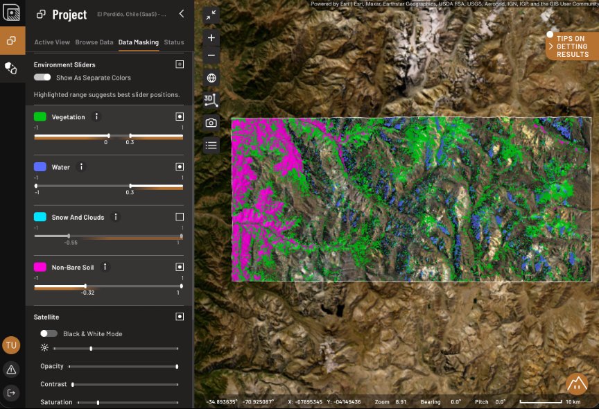
Set thresholds
For vegetation, set the first slider around 0 and the second around 0.2.
For water, you can set one slider around -1 and the other around 0.3.
Snow and clouds share an index, so you can use it interchangeably to filter out snow, clouds, or both – regardless of the terrain. If you want to mask snow, set the slider around -1 and the second around 0.7; for clouds use -0.1 and 0.2.
For non-bare soil put one slider around -0.3 and second around 1 it will help you to remove non-bare soil/rock pixels. We recommend setting 'non-bare soil' while the other three masks are turned off to check if it covers vegetated ground rather than outcrops.
Remember that values above should give you orientation, but the specific values are your decision.
Check surviving pixels
Pixels that survive masking can be analyzed in the Inspect tab in the Analogy Lab. There are reference vegetation curves available there which can be compared against. Look for the red edge, the sharp rise from about 700 nm that green vegetation always has. Still there? Lower the threshold. Dry vegetation is the one to watch: it isn't green, so it slips past the index, and it absorbs right next to the clay feature at 2200 nm.
What the masks won't remove
Masks will not remove man-made bare ground like tailings, dumps, quarry faces, haul roads, and artisanal pits. Crushed and dry ground often gives the strongest matches in the scene, so it's worth checking against the basemap imagery and marking the disturbed ground with a Shape Layer. This won't remove anything and can serve later as a note to yourself as you work.
Shadow. We recommend turning on Hillshade from inside of Data → Base & Context and leaving it on. Slopes facing away from the sun are not reflective enough to be reliable, and we can't mask them yet, so flag those candidates or drop them
Done when
Every available mask index is set for every provider and what's left looks like bare rock and soil.